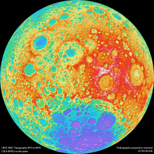
Okay, so we’re definitely space junkies that like to bring you the the word on cool, “out of this world” news outside of our atmosphere. The closest orb of interest? The moon. And we’ve been monitoring everything the Lunar Reconnaissance Orbiter has uncovered since its initial launch and historic mission to answer the many questions we have about Earth’s natural satellite. Due to technological and instrumental limitations, scientists have been unable to properly examine the moon’s many geologic formations, rugged terrain and total surface area – until now.
Yesterday NASA’s Lunar Reconnaissance Orbiter Camera (LROC) team revealed Version 1 of the Wide Angle Camera (WAC) high-resolution topographic map of the moon. This detailed color visualization was produced from a series of images captured by the WAC represents a significant turning point and advancement for lunar researchers. Llunar scientists can now research the geologic terrains to better prepare for future missions.
How The WAC Does This
Since the moon’s lighting changes every month based upon its orbit and relation to the sun, this amazingly small camera (it fits in the palm of your hand!) maps the entire moon each month and records how different rocks reflect light under certain conditions. The recorded observations are then added to the camera’s continuously-building LROC image archive for creating a shaded relief image, in which colors represent the varying altitude levels of the moon’s terrain. While another year of data has yet to be added to the existing model and improvements to camera quality are planned, the first version of the map already seems to be a bright start for lunar research.
For more information, check out: NASA’s Mission page for the LRO and ASU’s LROC Team site.


Why is the LROC website that lets you review the “entire” moon map doesn’t have the coordinates 65, 265 available for review?